NEWID ERYRI / CHANGING ERYRI

Arddangosfa chwilfrydig ei naws yw Newid Eryri. Mae’n taflu goleuni ar y newidiadau amrywiol a ddaeth i ran Eryri eisoes, gan gynnwys y prosesau cudd cynhenid sy’n siapio ein dealltwriaeth o’r dirwedd, y trawsnewidiadau ffisegol mwyaf amlwg a wnaed yn hanesyddol gan Stad y Penrhyn.
Mae'r arddangosfa yn archwilio tirwedd newidiol Eryri dros amser. Mae'r deunydd archifol a'r wybodaeth hanesyddol a rannwn yma’n canolbwyntio'n benodol ar Fethesda a Dyffryn Ogwen yn y gogledd orllewin.
Cynhaliwyd yr arddangosfa ryngweithiol yn Pontio, ym Mangor fis Awst 2024. Mae'r deunyddiau a gafodd eu harddangos bellach ar gael i bawb ar-lein yma. Mae llawer o’r delweddau’n cysylltu'n uniongyrchol â'r deunydd archifol yn Archifau a Chasgliadau Arbennig Prifysgol Bangor neu Llyfrgell Genedlaethol Cymru.
Newid Eryri is an inquisitive exhibition that shines a light on the diverse ways in which Eryri has already undergone change, from the hidden processes intrinsic to shaping our understandings of its landscape, to the more evident physical transformations undertaken by the historic Penrhyn Estate.
The exhibition explores the changing landscape of Eryri through time. The archive material and historic information shared here specifically focuses on Bethesda and Dyffryn Ogwen in Northwest Wales.
The interactive exhibition was hosted at Pontio, in Bangor during August 2024. The material on display has now been made available to all through this online space. Many images directly link to the archive material that is held by Bangor University Archives and Special Collections or The National Library of Wales.
Arddangosfa / Exhibition

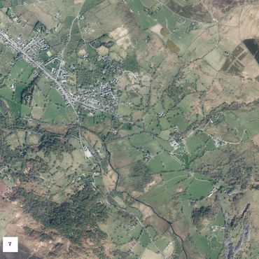
Datblygiad Bethesda
Ar ddechrau’r 19eg ganrif, daeth llawer o weithwyr i fyw i Ddyffryn Ogwen. Datblygodd Bethesda yn gyflym. Adeiladodd lawer o bobl eu cartrefi ar dir lle'r oedd prydlesi'n rhad a lle nad oedd y rheolau adeiladu yn llym. Roedd hyn yn golygu tir nad oed yn eiddo i’r Arglwydd Penrhyn.
Capel Bethesda, a adeiladwyd ym 1820, a roddodd ei enw i'r dref newydd. Cwblhawyd ffordd Thomas Telford, sy'n cysylltu'r Amwythig â Chaergybi (yr A5), ym 1820 hefyd. Dyma ddaeth yn stryd fawr y dref.
The birth of Bethesda
During the early 1800s, many workers came to live in Dyffryn Ogwen. Bethesda developed fast. Many people built their homes on land where leases were cheap and building rules were not strict. This meant not on land belonging to Lord Penrhyn.
Bethesda Chapel, built in 1820, gave its name to the growing town. Thomas Telford’s road, linking Shrewsbury with Holyhead (the A5), was also completed in 1820. It became the town's High Street.

Arglwydd Penrhyn, cynllunydd y dref
Cynyddodd poblogaeth Bethesda o 1,964 ym 1821 i 5,948 ym 1851.Etifeddodd Edward Gordon Douglas-Pennant Ystad y Penrhyn ym 1841. Prynodd fwy o dir yn Nyffryn Ogwen a chwaraeodd ran fawr yn y gwaith o foderneiddio Bethesda.
Ym 1854, helpodd i gyflenwi dŵr, carthffosiaeth, goleuadau a phennu safonau adeiladu ar gyfer y dref. Adeiladodd dai ym Mraichmelyn a Rhes Ogwen fel enghreifftiau i eraill eu dilyn hefyd.
Mae’r stryd gul, John Street, gyferbyn â Chapel Bethesda, yn olrhain hanes Bethesda o'r 1850au cynnar.
Lord Penrhyn, the town planner
Bethesda’s population rose from 1,964 people in 1821 to 5,948 in 1851. Edward Gordon Douglas-Pennant inherited the Penrhyn Estate in 1841. He purchased more land in Dyffryn Ogwen and played a big role in modernising Bethesda.
In 1854 he helped supply water, sewage, lighting and set building standards for the town. He also built model houses at Braichmelyn and Ogwen Terrace as examples for others to follow.
The narrow John Street, opposite Bethesda Chapel, is a trace of early 1850s Bethesda.

Cynlluniau at y dyfodol
Darparodd y mapiau fan cychwyn i benderfyniadau yn y dyfodol am werthu darnau o dir, datrys anghydfodau rhwng tirfeddianwyr a newid dulliau rheoli tir.
Map 3: Map o blwyf Llanllechid
Comisiynwyd y tri map mawr gan y Cadfridog Hugh Warburton a John Pennant ym 1768 i’w helpu i ddeall pa dir oedd ganddynt ym mhlwyfi Llanllechid a Llandegai.
Allwch chi ddod o hyd i'ch tŷ, neu leoedd rydych yn eu hadnabod?
Plans for the future
Maps provided a starting point for future decisions about sales, resolving disputes between landowners and bringing about land management change.
Map 2: Map of the parish of Llandegai
Map 3: Map of the parish of Llanllechid
These three large maps were commissioned by General Hugh Warburton and John Pennant in 1768 to help them understand what land they owned within the parishes of Llanllechid and Llandegai.
Can you find your house, or the places you know?

Lleoliad, lleoliad, lleoliad
Roedd y llyfr arolwg hwn yn dangos lleoliad eu tir i Richard Pennant ac Anna Susannah Warburton, a’u hasiantau, yn ogystal â phwy oedd yn byw ac yn gweithio yno.
Gwnaethpwyd y llyfr arolwg hwn fel cyfeirlyfr i’r tri map mawr sydd wedi eu harddangos uchod.
Location, location, location
This survey book showed Richard Pennant and Anna Susannah Warburton, and their agents, where the location of their land holdings were, as well as who lived and worked there.
This survey book was made as a reference to the three large maps on display above.
Cadw cofnod - cadw rheolaeth
Roedd llyfrau arolwg yn bwysig gan eu bod hefyd yn cadw cofnod o faint y tir, nifer yr adeiladau a'r swm yr oedd tenantiaid yn ei dalu mewn rhent.
Roedd asiantau Stad y Penrhyn yn cadw cofnodion helaeth fel bod yr Arglwydd a'r Arglwyddes Penrhyn yn gwybod beth oedd yn digwydd ar bob rhan o’r ystâd.
Keeping a record - keeping control
Survey books were important as they also kept a record of land sizes, buildings and the amount tenants paid in rent.
The Penrhyn Estate’s agents kept extensive records so that Lord and Lady Penrhyn knew what was happening almost anywhere across their estate.

Cadw llygad ar y gystadleuaeth
Roedd gwybod pwy oedd yn byw ac yn gweithio ar y tir yn bwysig i weinyddu newid, ond roedd gwybod pwy oedd yn berchen ar y tir yn bwysicach fyth.
Roedd y Pennantiaid bob amser yn chwilio am dir i’w brynu, felly roeddent yn cadw llygad barcud ar bwy oedd yn berchen ar dir ger eu hystâd. Mae’r llyfr hwn yn cynnwys adran sy'n rhestru tir nad yw'n eiddo i Ystad y Penrhyn.
One eye on the competition
Knowing who lived and worked the landscape was important for administering change, but it was even more important for knowing who owned the land.
Always looking for a new purchase, the Pennants kept a close eye on who owned land near their Estate. This book has a section listing land not belonging to the Penrhyn Estate.

Prif asiantau newid
Yr asiant tir oedd y dirprwy ac roedd rheolaeth Ystad y Penrhyn yn ei ddwylo ef.
Anfonwyd y canllawiau drafft a ysgrifennwyd i denantiaid at yr Arglwydd Penrhyn gan James Wyatt, yr asiant tir rhwng 1814 a 1859. Mae'r canllawiau drafft yn cynnwys geiriau wedi eu croesi allan a chymalau wedi eu haralleirio.
A ydych yn meddwl bod cadw’r cytbwysedd rhwng gweledigaeth yr Arglwydd Penrhyn a chynnal perthynas dda gyda’r tenantiaid yn anodd?
Disgrifiwyd swydd asiant tir fel ‘hunting with the hounds and running with the hare’.
Key agents of change
The land agent was second in command, and the managing the Penrhyn Estate was in their hands. This draft guidance written for tenants was sent to Lord Penrhyn by James Wyatt, the land agent between 1814 and 1859.
The draft guidance includes crossed out words and rephrasing.
Do you think he was finding it difficult to negotiate between Lord Penrhyn’s vision and keeping good relationships with tenants?
The land agent’s job was described as ‘hunting with the hounds and running with the hare’.
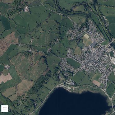
Ai fel hyn y bu erioed?
Mae’r dirwedd amaethyddol ger Castell Penrhyn yn edrych fel llawer o dirweddau eraill ledled Cymru.
Ai dyma beth sy’n dod i’ch meddwl wrth feddwl am gefn gwlad Cymru?
Mae'r fideo hwn a wnaed ar lefel y ddaear yn dangos yr un ardal a ddangosir ar fap 1849 ac yn yr awyrlun isod.
Is this how it has always been?
This agricultural landscape near Penrhyn Castle looks like many others across Wales.
Is this what you picture when thinking of the Welsh countryside?
This video taken at ground-level shows the same area depicted in the 1849 map and aerial photograph below.

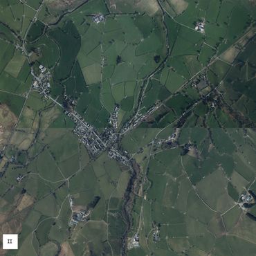
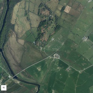
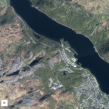
Ffiniau yn y dirwedd
Sut mae ffiniau'r caeau wedi newid ers 1849?
Pa mor hen yw'r tirweddau amaethyddol sydd i’w gweld heddiw?
Mae'r awyrlun hwn yn dangos yr un ardal a gynrychiolir ar y map 1849, isod.
Boundaries in the landscape
How have the field boundaries changed since 1849?
How old are the agricultural landscapes we know today?
This aerial photograph shows the same area represented in the 1849 map below.
Dod â threfn i'r tir
Newidiodd Edward Gordon Douglas-Pennant gymeriad y tir isel. Ail-drefnodd y caeau fel eu bod yn debyg o ran maint a chyda ffiniau ar onglau sgwâr. Cynghorodd a darbwyllodd asiant Ystad y Penrhyn y tenantiaid i newid y ffordd yr oeddent yn ffermio.
Mae'r map hwn, o 1849, yn dangos gweithrediad cynllun uchelgeisiol Douglas-Pennant. Mae'r llinellau du trwchus syth ar y map yn cynrychioli ffiniau newydd y caeau. Mae'r llinellau pensil toredig yn cynrychioli'r caeau afreolaidd gwreiddiol gyda ffiniau troellog.
Defnyddiwyd yr un dull i sythu ffiniau caeau yn y tir uchel.
A ydych erioed wedi meddwl pam fod waliau terfyn/ffensys mor syth?
Bringing order to the landscape
Edward Gordon Douglas-Pennant changed the character of the lowland landscape. He had the fields reshaped so they were similar sizes and had right-angled boundaries. The Penrhyn Estate agent's advised and influenced tenants to change the way they farmed.
This map, from 1849, shows the execution of Douglas-Pennant’s grand plan. The straight thick black lines on the map represent the new field boundaries. The dashed pencil lines represent the older irregular fields that had sinuous boundaries.
The same approach to straightening field boundaries was taken in the uplands.
Have you ever wondered why boundaries walls/fences were so straight?
Arferion 'dinistriol a llafurus'
Roedd dros 20,000 o bobl yn ffermio ar Ystad y Penrhyn ar un adeg. Gyda gweithlu mor fawr, roedd Edward Gordon Douglas-Pennant yn awyddus i newid arferion amaethyddol a chynyddu lefelau cynhyrchu.
Mae'r pamffled hwn, a gynhyrchwyd yn Gymraeg a Saesneg, yn cynghori ei denantiaid ar ffyrdd newydd o ffermio ac yn disgrifio arferion hŷn fel rhai 'dinistriol a llafurus'.
‘Ruinous and exhausting’ practices
Over 20,000 people once farmed on the Penrhyn Estate. With such a workforce, Edward Gordon Douglas-Pennant was eager to change agricultural practices and increase production levels.
This pamphlet, produced in Welsh and English, advises his tenants on new ways of farming and describes older practices as ‘ruinous and exhausting’.
Y blynyddoedd ar ôl y rhyfel
Ym 1939, roedd llai na 60,000 o dractorau ar ffermydd Prydain. Erbyn 1955, roedd 532,000 o dractorau.
Ar ôl yr Ail Ryfel Byd, ceisiodd y llywodraeth ysgogi cynhyrchiant a thwf. Gorfododd hyn ffermwyr i fod yn fwy effeithlon a gwneud eu tir yn fwy cynhyrchiol.
Bu ffermwyr yn trin tir newydd, yn draenio corstiroedd, yn aredig rhostiroedd ac yn cael gwared â choedwigoedd a gwrychoedd.
Yn ystod y 1960au, dyfnhawyd Afon Ogwen i leihau llifogydd a chynyddu’r tir pori.
Mae'r adroddiad hwn o'r 1990au yn disgrifio sut gwnaeth y project i adfer yr afon wella llif yr afon.
The post-war years
In 1939 there were fewer than 60,000 tractors on British farms. By 1955, there were 532,000 tractors.
After World War 2 the government sought to drive productivity and growth. This forced farmers to be more efficient and make their land more productive.
Farmers cultivated new land, drained marshland, ploughed moorland and removed woods and hedgerows.
During the 1960s, Afon Ogwen was deepened to reduce flooding and increase livestock grazing.
This 1990s report describes how the River Restoration Project improved the river's flow.
Rheoli a chynllunio newid
Dechreuodd Ystad y Penrhyn werthu ei thir ar ddechrau’r 20fed ganrif. Yn ystod y cyfnod hwn, roedd llawer o denantiaid yn gallu prynu eu ffermydd a'u cartrefi.Mae llawer o’r tir a oedd yn rhan o Ystad y Penrhyn bellach yn cael ei reoli gan y cyrff canlynol neu yn eu meddiant: Cyfoeth Naturiol Cymru, Yr Ymddiriedolaeth Genedlaethol, Awdurdod Parc Cenedlaethol Eryri, Ystad y Goron, a llawer o dirfeddianwyr preifat.
Mae'r adroddiadau hyn, y dogfennau rheoli a chynlluniau'r dyfodol yn dangos bod newidiadau yn parhau i ddigwydd.
Managing and planning for change
In the early 20th century, the Penrhyn Estate began selling off land. During this time many tenants were able to buy their farms and homes.
A lot of the land that was part of the historic Penrhyn Estate is now owned or managed by: Natural Resources Wales, The National Trust, Snowdonia National Park Authority, The Crown Estate, and many private land owners.
These reports, management documents and future plans show that change is ongoing.

Ffiaidd, anghysbell a
di-fudd
Irywun oedd yn byw 300 mlynedd yn ôl, roedd mynyddoedd, dyffrynnoedd a chorsydd gogledd Cymru yn olygfa anaddas i’r gymdeithas fodern.
Roedd rhai hyd yn oed yn awgrymu y dylid defnyddio lleoedd fel Eryri i waredu rwbel o’r paradwysau mwy dymunol a ddyluniwyd gan arddwyr fel Capability Brown.
Revolting, distant and unproductive
To someone 300 years ago, the mountains, valleys and bogs of north Wales were a sight unfit for a modern society.
Some even suggested that places like Eryri were dumping grounds for the rubble of the more desirable highly designed paradises created by gardeners like Capability Brown.

'The Country looks like the fag End of Creation; the very Rubbish of Noah’s Flood; and will (if anything) serve to confirm an Epicurean in his Creed, That the World was made by Chance.'
Unknown, 1776
'At one end is the ocean, at the other the formidable mountains of Snowdon, black and naked rocks which seemed to be piled one above the other. The summits of some of them are covered with clouds, and cannot be ascended. They do altogether strongly excite the idea … of their being the fragment of a demolished world.'
George Lord Lyttleton, 1781
‘Upon entering the cwm [Cwm Idwal], strangers have stood aghast for the moment, appearing more like fixed statues than animated nature; the mind is instantly filled with thoughts accordant to the horrific gloom and melancholy that pervade the vast profundity of this British Pandemonium; the awful and formidable black precipices, the
‘Upon entering the cwm [Cwm Idwal], strangers have stood aghast for the moment, appearing more like fixed statues than animated nature; the mind is instantly filled with thoughts accordant to the horrific gloom and melancholy that pervade the vast profundity of this British Pandemonium; the awful and formidable black precipices, the nearly surround the dismal pool, forming a wonderful amphitheatre, mysteriously reared by the magic spell of nature…'
Thomas Pennant,
Tours in Wales, 1810
'If you would be sublimely captivated, visit Nant Ffrancon or Nant Gwynant. Range along these crags and precipices, where nature, bold and rough, sits alone, majestic on her craggy throne. There rove, transported among scenes so awful and sublime, that the breath is suspended, while the eye is gazing upon wonders; there where the ra
'If you would be sublimely captivated, visit Nant Ffrancon or Nant Gwynant. Range along these crags and precipices, where nature, bold and rough, sits alone, majestic on her craggy throne. There rove, transported among scenes so awful and sublime, that the breath is suspended, while the eye is gazing upon wonders; there where the race of man seems extinct, where not a tree, shrub, nor cottage, remind him of the solemn roars of the wind, he cries of the eagle, and the screams of the kite. Pursue the windings of the defile, stand upon the edge, and cast your eyes below!'
Cambrian Mirror Newspaper, 1848
Tirweddau perffaith a thirweddau anghofiedig
Ar ddiwedd y 1700au, roedd arlunwyr ac awduron llyfrau teithio yn chwilio am leoedd 'digyffro', 'anghofiedig' a 'gwyllt' yn Eryri. Roeddent eisiau lleoedd heb ôl y diwydiannu a oedd yn digwydd ledled Prydain.
I ba raddau mae pobl yn dal i feddwl am Eryri fel hyn?
Picture perfect landscapes and those left forgot
In the late 1700s, artists and travel writers looked for the ‘undisturbed’, ‘forgotten’ and ‘wild’ in Eryri. They wanted places which they believed were untouched by the industrialisation happening across Britain.
How far do people still think about Eryri like this?
Arian, seilwaith a chynhyrchu
Ariannodd y teulu Pennant ffyrdd, rheilffyrdd a bu iddynt hyd yn oed geisio adeiladu camlas o'r chwarel i'r Fenai. Cynyddodd eu hasiantau’r cynnyrch amaethyddol, ymestynnwyd y chwareli, a’u cysylltu â’r marchnadoedd byd-eang.
Buddsoddodd y Pennantiaid symiau enfawr o arian yn Ystad y Penrhyn. Daeth yr arian hwn
Arian, seilwaith a chynhyrchu
Ariannodd y teulu Pennant ffyrdd, rheilffyrdd a bu iddynt hyd yn oed geisio adeiladu camlas o'r chwarel i'r Fenai. Cynyddodd eu hasiantau’r cynnyrch amaethyddol, ymestynnwyd y chwareli, a’u cysylltu â’r marchnadoedd byd-eang.
Buddsoddodd y Pennantiaid symiau enfawr o arian yn Ystad y Penrhyn. Daeth yr arian hwnnw o lafur caethweision a oedd yn gweithio ar eu planhigfeydd siwgr yn Jamaica.
Trawsnewidiodd y Pennantiaid, eu hasiantau a’u tenantiaid Eryri yn dirwedd gynhyrchiol.
Money, infrastructure and production
The Pennant family funded roads, railways and even tried to build a canal from the quarry to the Menai. Their agents increased agricultural production, expanded quarrying, and connected their operations to the global markets.
The Pennants invested vast amounts of money into the Penrhyn Estate. That money
Money, infrastructure and production
The Pennant family funded roads, railways and even tried to build a canal from the quarry to the Menai. Their agents increased agricultural production, expanded quarrying, and connected their operations to the global markets.
The Pennants invested vast amounts of money into the Penrhyn Estate. That money came from the labour of enslaved people working their sugar plantations in Jamaica.
The Pennants, their agents and tenants transformed Eryri into a productive landscape.
'When I last visited these parts some years ago there was no accommodation even for the fisherman or even a pedestrian-tourist, but the public zeal of the late Lord Penrhyn has remedied all these inconveniences by establishing a large and commodious inn at Capel Cerrig and by rendering the rough places plain. The whole country is now beco
'When I last visited these parts some years ago there was no accommodation even for the fisherman or even a pedestrian-tourist, but the public zeal of the late Lord Penrhyn has remedied all these inconveniences by establishing a large and commodious inn at Capel Cerrig and by rendering the rough places plain. The whole country is now become practicable in every direction, and a chaise rolls on with ease and safety where a timid equestrian would not have ventured.'
Sir Richard Colt Hoare, 1810
'Exclusive of the interest arising from the grandeur of the scenery, the traveller has now the opportunity of being gratified in the course of his excursion with a sight of Ogwen Bank, the slate quarries, the well-constructed railways, and the great and various improvements effected by the late Lord Penrhyn in the previously desolate tract of Nant Francon.'
Thomas Pennant, 1810
'It was like a subterranean world! Above the blasted walls of slate, smooth as a mirror and several hundred feet high, scarcely enough of the blue heaven was visible to enable me to distinguish mid-day from twilight. The ground on which we stood was likewise blasted rock; just in the middle was a deep cleft six or eight feet wide. Some of
'It was like a subterranean world! Above the blasted walls of slate, smooth as a mirror and several hundred feet high, scarcely enough of the blue heaven was visible to enable me to distinguish mid-day from twilight. The ground on which we stood was likewise blasted rock; just in the middle was a deep cleft six or eight feet wide. Some of the children of the workmen were amusing themselves in leaping across this chasm for a few pence.'
Hermann Ludwig Heinrich von Pückler-Muskau, 1828
'The most important effect of machine production on the imaginative picture of the world is an immense increase in the sense of human power... In old days, mountains and waterfalls were natural phenomena; now, an inconvenient mountain can be abolished and a convenient waterfall can be created. In old days, there were deserts and fertile r
'The most important effect of machine production on the imaginative picture of the world is an immense increase in the sense of human power... In old days, mountains and waterfalls were natural phenomena; now, an inconvenient mountain can be abolished and a convenient waterfall can be created. In old days, there were deserts and fertile regions; now, the desert can, if people think it worth while, be made to blossom like the rose...'
Bertrand Russell, 1945
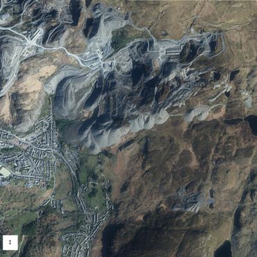
Synnu at allu pobl i ddofi natur
A ydych yn meddwl bod Chwarel y Penrhyn yn brydferth?
Erbyn diwedd y 18fed ganrif, roedd y Chwyldro Diwydiannol wedi dangos meistrolaeth dyn dros natur.Newidiodd hyn feddwl y gymdeithas ym Mhrydain am dirweddau diwydiannol. Arweiniodd maint lleoedd fel Chwarel y Penrhyn at lawer o artistiaid a thwristiaid yn
Synnu at allu pobl i ddofi natur
A ydych yn meddwl bod Chwarel y Penrhyn yn brydferth?
Erbyn diwedd y 18fed ganrif, roedd y Chwyldro Diwydiannol wedi dangos meistrolaeth dyn dros natur.Newidiodd hyn feddwl y gymdeithas ym Mhrydain am dirweddau diwydiannol. Arweiniodd maint lleoedd fel Chwarel y Penrhyn at lawer o artistiaid a thwristiaid yn troi eu sylw at dirweddau oedd yn dangos gallu pobl i ddofi natur.
In awe of human’s taming nature
Do you think Penrhyn Quarry is beautiful?
By the late 18th century, the Industrial Revolution displayed human’s mastery over nature. This changed British society’s mind about industrial landscapes. The pure scale of places like Penrhyn Quarry led many artists and tourists turning their attention from the awe of nature to the awe of man’s power over nature.
Eryri a Chymreictod
Wrth i Gymru fynd yn fwy diwydiannol, mudodd miloedd o bobl o’r pentrefi i'r dinasoedd. Dechreuodd y Cymry goleddu mynyddoedd, dyffrynnoedd, clogwyni a choedwigoedd Cymru. Mae anthem genedlaethol Cymru, a ysgrifennwyd ym 1856, yn dyst i'r newid hwn ym marn y Cymry.
Dechreuodd y gwerthfawrogiad o gefn gwlad a syniadau am hunaniaeth leol ddylanwadu ar wleidyddiaeth yng Nghymru ar ddechrau’r 20fed ganrif.
Eryri and Welsh identity
As Wales became more industrialised, thousands of people emigrated from villages to the cities. Welsh society began to cherish the mountains, valleys, precipices and forests of Wales. The Welsh national anthem, written in 1856, is a testament to this change in Welsh society’s view.
The appreciation of the countryside and ideas about local identity influenced early 20th-century Welsh politics.
Cadw'r dref draw!
Mae tair deddf yn gosod y sylfaen i system bresennol Prydain o wneud penderfyniadau ynglŷn â thirwedd - Deddf Amaethyddiaeth (1947); Deddf Cynllunio Gwlad a Thref (1947); a Deddf Parciau Cenedlaethol a Mynediad i Gefn Gwlad (1949).
Mae’r awydd i warchod cefn gwlad wrth wraidd y deddfau hyn: arweiniodd y drydedd ddeddf at g
Cadw'r dref draw!
Mae tair deddf yn gosod y sylfaen i system bresennol Prydain o wneud penderfyniadau ynglŷn â thirwedd - Deddf Amaethyddiaeth (1947); Deddf Cynllunio Gwlad a Thref (1947); a Deddf Parciau Cenedlaethol a Mynediad i Gefn Gwlad (1949).
Mae’r awydd i warchod cefn gwlad wrth wraidd y deddfau hyn: arweiniodd y drydedd ddeddf at greu Parc Cenedlaethol Eryri.
Ar ôl yr Ail Ryfel Byd, roedd y llywodraeth yn credu mai'r bygythiad mwyaf i gefn gwlad oedd ehangu trefol. Dewisodd y llywodraeth eithrio tirfeddianwyr gwledig o'r holl ofynion cynllunio bron cyn belled â’u bod yn cadw eu tir at ddefnydd amaethyddol.
Fodd bynnag, methodd y freuddwyd o ‘dirwedd draddodiadol a hardd Brydeinig' a ddisgrifiwyd yn y tair deddf â rhagweld y trawsnewidiad digynsail mewn ffermio ar ôl y rhyfel, y dinistr ecolegol a ddilynodd, a'r canlyniadau i gymunedau gwledig.
Keeping the town at bay!
Three Acts lay the ground for Britain’s current landscape decision-making system - the Agriculture Act (1947); the Town and Country Planning Act (1947); and the National Parks and Access to the Countryside Act (1949).
At the core of these Acts was the desire to preserve the countryside: the third one led to the crea
Keeping the town at bay!
Three Acts lay the ground for Britain’s current landscape decision-making system - the Agriculture Act (1947); the Town and Country Planning Act (1947); and the National Parks and Access to the Countryside Act (1949).
At the core of these Acts was the desire to preserve the countryside: the third one led to the creation of Eryri National Park.
After World War 2, governments believed that the greatest threat to the countryside was urban expansion. They chose to exempt rural landowners from nearly all planning as long as they kept their land in agricultural use.
However, the dream of a ‘traditional’, ‘picturesque British landscape’ described in the three Acts failed to anticipate the unprecedented transformation in post-war farming, the ecological destruction that followed, and the consequences for rural communities.
‘We have suddenly awakened to the fact that we must preserve certain parts of our islands ... In Wales we have mentioned Snowdonia.
These ideas must be taken seriously, and a new patriotism founded on a more intelligent love of our country. We want to see industrial litter cleared. Derelict works and abandoned dwellings, which disfigure
‘We have suddenly awakened to the fact that we must preserve certain parts of our islands ... In Wales we have mentioned Snowdonia.
These ideas must be taken seriously, and a new patriotism founded on a more intelligent love of our country. We want to see industrial litter cleared. Derelict works and abandoned dwellings, which disfigure land and render districts desolate, we want to see demolished, and trees planted where they stood.'
Major Clough Williams-Ellis, 1929